Vandergriff
Randolph County, Arkansas, USA – *No GPS coordinates
About
-
Stubblefield Farm
No GPS information available Add GPS
- Cemetery ID:
Members have Contributed
- 2 Memorials
- 0% photographed
- No location information available Add Location
Advertisement
Photos
No additional photos.
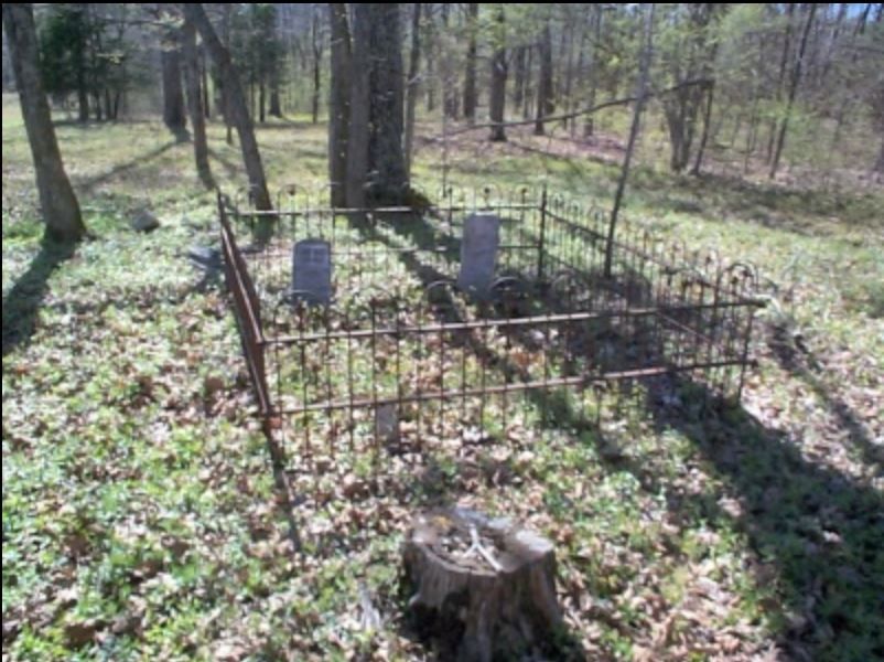
Add PhotosBurial Site of Ruffin & Jane Vandergriff near Dalton, Arkansas. This site is located on the present day (2003) farm of Perry H Stubblefield on Highway 93 about 8 miles south of Dalton, Arkansas and just a short distance north of Stubblefield Road. Directions to the burial site from Pocahontas are: Take Highway 90 West to the intersection of Highway 93, turn right, proceed 1.1 miles where you will find a closed gate on the left. (just across the highway from the gate will be Townsend chicken farms) Beyond the gate is a rough road leading back to the woods and a cattle farm. After proceeding through the gate, go .1 mile to a lane on the left leading back to the field. Follow lane, bearing to the right, 1/4 mile. The cemetery is located on top of a hill in a wooded area. GPS coordinates are: 36° 21' 47" N 91°06' 06" W. The burial site is enclosed in a wrought iron fence and was clean at the time of our visit. There are no other known burials, here.
by Lee and Betty Tucker, April 10, 2003.
Burial Site of Ruffin & Jane Vandergriff near Dalton, Arkansas. This site is located on the present day (2003) farm of Perry H Stubblefield on Highway 93 about 8 miles south of Dalton, Arkansas and just a short distance north of Stubblefield Road. Directions to the burial site from Pocahontas are: Take Highway 90 West to the intersection of Highway 93, turn right, proceed 1.1 miles where you will find a closed gate on the left. (just across the highway from the gate will be Townsend chicken farms) Beyond the gate is a rough road leading back to the woods and a cattle farm. After proceeding through the gate, go .1 mile to a lane on the left leading back to the field. Follow lane, bearing to the right, 1/4 mile. The cemetery is located on top of a hill in a wooded area. GPS coordinates are: 36° 21' 47" N 91°06' 06" W. The burial site is enclosed in a wrought iron fence and was clean at the time of our visit. There are no other known burials, here.
by Lee and Betty Tucker, April 10, 2003.
Nearby cemeteries

Pocahontas, Randolph County, Arkansas, USA
- Total memorials5k+
- Percent photographed89%
- Percent with GPS86%

Pocahontas, Randolph County, Arkansas, USA
- Total memorials2k+
- Percent photographed91%
- Percent with GPS85%

Reyno, Randolph County, Arkansas, USA
- Total memorials1k+
- Percent photographed85%
- Percent with GPS9%

Maynard, Randolph County, Arkansas, USA
- Total memorials1k+
- Percent photographed88%
- Percent with GPS19%
- Added: 14 Sep 2023
- Find a Grave Cemetery ID: 2785875

Cemetery Photos
This is a carousel with slides. Use Next and Previous buttons to navigate, or jump to a slide with the slide dots. Use Escape keyboard button or the Close button to close the carousel.
Success
Uploading...
Waiting...
Failed
This photo was not uploaded because this cemetery already has 20 photos
This photo was not uploaded because you have already uploaded 5 photos to this cemetery
This photo was not uploaded because you have already uploaded 5 photos to this cemetery
Invalid File Type
Birth and death years unknown.
1 photo picked...
2 photos picked...
Uploading 1 Photo
Uploading 2 Photos
1 Photo Uploaded
2 Photos Uploaded
Size exceeded
Too many photos have been uploaded
"Unsupported file type"
• ##count## of 0 memorials with GPS displayed. Double click on map to view more.No cemeteries found